Google Maps with Navigation

This past weekend presented my first opportunity to try Google’s navigation service which is built on top of Google Maps in Android.  As with most things in Android directions (walk, drive and transit) are well contextualized within many places.  This contextual awareness is definitely a key strength of Android as a platform …

Anyway, I was looking for a piece of AV gear and decided to try my nearest Best Buy which I found via Google Maps and then took the opportunity to use navigation to get there.  I’ve got GPS in the car already, but figured a live test would be good … and as my GPS in the car has maps that are 5 years old, I thought I might have better luck.

Navigation started right away and the audible directions were clear if not a bit robotic…. to be expected.  When it seemed like I was there yet with no sign of the store, I thought something might be wrong.  I tried my iPhone’s Google Maps which also reported (to be expected) the same information and eventually had to fall on my manly pride and ask for directions.  The address info on the map was completely wrong and while GPS steered me properly, there was no way to find the destination.

I eventually found the store, waited patiently and discovered they did not have what I wanted.  Time could have easily have been saved using Google Shopper, or perhaps even the actual phone. (the horror!)

On the way home, I again used the phone to navigate even though I knew how to go … this time however the route plotted was a bit different than the way out and I lost connectivity a few times (AT&T) and as a result the navigation became confused.  It wasn’t until my connection was restored that my navigation was again able to be used properly.

Two key lessons …

  1. Phones are fickle as GPS devices (still) required a live data connection even for plotted routed.
  2. Navigation systems are only as good as the data on the map.

I’d still recommend Google Navigation … It looks beautiful and the audible prompts are easy to follow.  It’s an amazing free addition …

13 months, 4,000 miles

Garmin Connect - Cycling Report

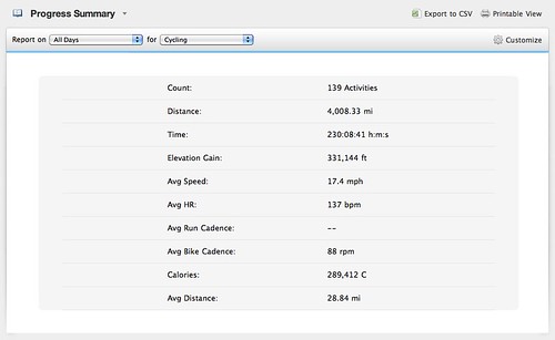
With this morning’s ride, I cleared 4,000 miles which I find very cool. I bought my bike last July and have ridden regularly for most of the year. There was some lag time over the winter due to weather, but I’ve been generally consistent.

My morning loops started around 20 and tend to be closer to 25 miles which is about the maximum I can do and still make my train to work. Weekends I try to go longer with 45 miles on average though if I can get the time I like to go much longer.

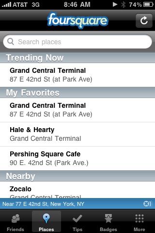
Currently trending on Foursquare

@foursquare Trending Now

This is a very cool new way to show the live nature of the service …

This used to be what I had done in a particular area but seems to be
expanding quite nicely to include the broader population.  With a check-in happening  every second, this really becomes a real-time view into the world around you.

Foursquare currently works via app on iPhone, Android, Maemo and soon Blackberry. You can check-in via mobile web as well if you like. The latest update even let’s you (finally) check-in via GPS, so you no longer need an exact address.

Apple’s cooking their own Social Location

Not too surprising to see, and frankly not real yet … 9to5Mac reports on a patent that covers a pending piece of Apple tech to match and enhance the capabilities currently found in Latitude – at least on the surface.  The goodies within the patent seem to indicate that geo-data will be able to extend to both sms and instant messages making it more of a system wide feature.

I’m hoping this leads to a more standard way to handle location data.  Apple seems “good enough” to start as a source for handling this … I just hope it’s not restricted to Apple only things.  That would be a very Nokia-like approach (Friendview anyone?) and one that while successful within it’s own world, would severely limit the opportunity.  On second thought it does actually sound a lot like what’s baked into Nokia Chat Ovi Contacts.

Location, location, location!

In the past few years, I feel like I’ve tried just about every location service.  Some have certainly offered more than others, but one thing has been sadly consistent and that’s absolutely no consistency in access to your data.  If 2010 can bring one thing, I hope it’s a simplified and federated view into our location data.

Social location services are a very interesting area.  I’ve dabbled across various apps to try and find the magic but have come up short.  The potential is there, but because no one service or perhaps suite of tools enables

  • the right degree of privacy control
  • proactive friend notifications
  • base of users and importantly a way to contact each other either publicly or privately

A quick look back at the list of things I’ve tried in no particular order… Jaiku, Twitter, Latitude, Nokia FriendView, Loopt, Brightkite, waze, Stalqer, dopplr, tripit, fire eagle, Foursquare and Gowalla.  Of all these, only Fire Eagle and Dopplr currently talk and a quick check on Fire Eagle tonight revealed I am in Singapore yet I write this from Katonah, NY.  Dopplr actually knows that’s where I am but for some reason has not shared this info with FE … not that it matters for now.

There’s a clear issue with all of this.  There is no way to share my location data easily across services and situations.  Instead I have to explicitly state or open the app I want to use in order to have things update and shared across my social network.   Unlike status messages, location is not a subjective thing, it’s actual.  You can and should be able to share the degree of accuracy people see and Latitude does this well.  Even the two competing check-in services FourSquare and Gowalla do it differently… Foursquare requires and address if you want the place to be used by others while Gowalla places a pin on the map via GPS.  I prefer the GPS method personally as I almost never know or want to take the time to find the address to simply check-in.  If I fire Latitude up my location will be highlighted within a few moments, but that’s not something I can actually use.

Speaking of using … the three points I was initially making all clearly tie together.

  • I need to have total control over how my location information is shared.  I rarely want to show when I am in my home, but showing the town is cool.
  • With friends in the system, I want to know when they are close and see that as prioritized info in whatever view I’ve got within the app.  For some reason this is not the case with anything.  Latitude sorts randomly when you browse the map, Foursquare sorts by time and Foursquare, Gowalla and Stalqer give me updates on everyone regardless of where they are.  While there are some modifiable settings, it’s not even close to granular enough to be valuable in this context.
  • Having friends in the system is important and since this space is still fragmented there are too many options to choose from to find your friends.  Stalqer did an admirable job linking through Facebook, but Facebook doesn’t actually have a native location system.

Twitter and Facebook will probably duke this out in the end with some competition from Google.  Currently twitter supports location and you can geo-tag tweets via various mobile clients, but this information is so hidden from the main view, it’s essentially a waste to even bother.  Google has quite a few pieces behind the scenes, but so far has not taken them anywhere.  You’ll notice I’ve got a location widget on the sidebar of my blog which will show city-level views via Latitude.  Other than that Latitude is mainly a view only layer on Maps.

I’m sure 2010 will be a hype filled year for location services.  I’m really hoping we’ll see standards that will let these things work together.  I don’t want to entrust my location data to a single provider (yet) though if someone was able to develop the right open federation model it would make things very interesting.

You have 10 minutes to get the F— out!

Location based services are something that’s been hyped for a years now. While everyone has heard of the coupon from Starbucks example, how about a real world practical use case?  The emergency system in Israel is the first time I’ve heard of anything like this and sounds very impressive.

The 10 minute warning system that Israel has been using to notify civilians in the vicinity of structures they will be bombing is fascinating. I could not find an online description of the system but the way it works is that civilian neighbors of a structure that will be attacked are given a 10 minute warning by phone to evacuate the area. It appears to be fairly precise given the counterproductive nature of giving evacuation warnings across too broad of an area.

Think for a second about what it would take to make such a system effective. First and foremost, they would have to have a map of every structure in Gaza, which is clearly something Google does on a daily basis, but then they would have to have a database of phone numbers attached to every person in each structure (remember this is predominately a mobile based telecom system). [Venture Chronicles]

Quick N85 and N79 Photo Test

Just getting going with both the new devices and decided to snap a quick picture following breakfast today …

First the N85:

12/24/2008 - N85 Close Mode Pancakes

And now the N79:

12/24/2008 - N79 Close Mode Pancakes

Aside from the “pilot error” in focusing on slightly different parts of the plate, I’d call this pretty even. Both devices offer Carl Zeiss 5MP AutoFocusing optics and response time is excellent. The N85 had a much easier time acquiring my position over A-GPS, but that’s thanks to AT&T vs the T-Mobile TZones connection of my other SIM card.

Meet the Nokia N97 – The New Nseries Flagship!

12012008258 - Share on Ovi

(more pictures to come – need more connection speed!)

Today Nokia announced the Nokia N97, the new flagship of the Nseries line.  The N97 brings a QWERTY keyboard to Nseries for the first time as well as continuing the touch UI (S60 5th Edition) introduced in the 5800 Express Music.  The home screen is all new and what I can only describe as a widget-top, giving you instant access to content that matters to you in your connected life.

There’s a clear emphasis on context which enables you to get both geographically and time sensitive information delivered at a glance.  The N97’s homescreen will be customizable to allow both Nokia and 3rd party developers to activate WRT (Web Runtime) widgets without having to launch an application.   Essentially live feeds at a glance.  For the connected the social networking enthusiast, this will be a must have device.

The keyboard slides and tilts from the longer side revealing a very comfortable raised typing surface.  While I only had a limited time to type around it seemed very easy to get used to and absolutely like something on which I could do ton of messaging.  It’s great to see QWERTY FINALLY on an Nseries!  Nokia has typically made you choose between E and N series for a device that does what you want most of the time and with the N97 there’s finally a single unit that can handle everything.

The new homescreen is an awesome way to provide direct access to information within an instant.  During our briefing with Nokia we learned that they consider the N97 a new category of device and one that is more a mobile computer than the prior generation of multimedia computers.  The N97 offers a massive amount of functionality in a very reasonably sized package.  The screen is 640×360 and is just gorgeous.  Contrast was excellent and colors (all 16 Million of them) seemed quite vibrant!  You can customize every part of the homescreen which is remarkably something that we’ve not had previously in S60 devices.  You can add, remove or just slide any of the widgets around to make things just how you like them.  When you rotate the device between portrait and landscape modes, things nicely re-align.

On first glance the N97 compares to the 5800 in size and seems like it’s older brother … until you slide the keyboard out and realize you’ve got an altogether new breed in hand.  While it’s not a small device, the N97 feels great in your hand and can easily be used while walking without needing two hands in most cases.  The virtual keyboards (numbers and T9) were clear and the softkeys seemed eas to access for quick data entry.  Of course for larger text needs a quick flip and you’ve got a real keyboard at your disposal.  Weight (Approx. 150 g) felt semi-comparable to the E71 and in the front pocket of my jeans it was not in any way uncomfortable.

There’s much more to this device than I can possibly do justice in an initial post.  When this goes live I’ll be listening to the keynotes and will report back after further Q&A.

Nokia Sportstracker Mobile Mapping

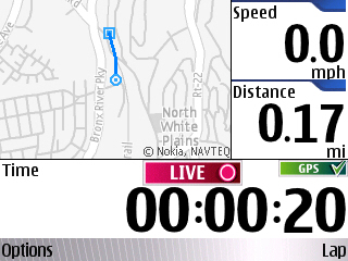
Sportstracker mobile mapping

Thanks to Jaiku and GerryMoth I just learned about a new release of Sportstracker which offers a real map of your location as you track your progress.  Previous versions showed a visual progress, but based on coordinates rather than a real map.  i believe this is the first integration of Navteq data outside the Maps application and it is working really well.

Nokia N82 revealed through a Virtual Live Event!

This morning while on the train, I was able to join the Virtual live event for the Nokia N82 launch via my Nokia N810 tablet connected over DUN to the N95. A pretty cool way to experience something like this and I believe I’m the only one who even attempted this.

Nokia virtual event streaming via 3G to the N810!

The event has a pretty massive array of streaming content, downloads and a rather active chat. Initially I thought I’d be missing the actual experience as the page took quite a while to load – even once my 3G service activated while heading south to NYC. Anyway – a very cool way to enable a much broader audience to take part in something only a few would have been able to do otherwise.

Now, the N82 is one hot device! It’s basically everything you get from the N95, in a candybar form, like the N73 before it. You get GPS, Wifi with VOIP capabilities, 100MB of dynamic memory for as you need it power! The addition of the Xenon flash is also killer and sure to improve your image capture — and a real hero feature for the device. I hope this is standard for N-Series moving forward. Reading the spec sheet I see that Nokia is also going to pre-load maps for your region on a memory card which is a great way to enhance your out of the box experience. This is exactly what they are doing on the N810 – which matches the N82 very nicely by the way!

The only bummer on the N82 is that it’s not going to support US 3G which makes it impossible for me to consider for the time being. Regardless though, for the rest of the world, (and the vast majority of Nokia’s market share) this is a killer mobile!